Wang Tong Fm
Period:
Ordovician, Silurian
Age Interval:
Upper Ordovician to Lower Silurian (Upper Ashgill to Llandovery) (3)
Province:
Sibumasu: Lower Peninsula
Type Locality and Naming
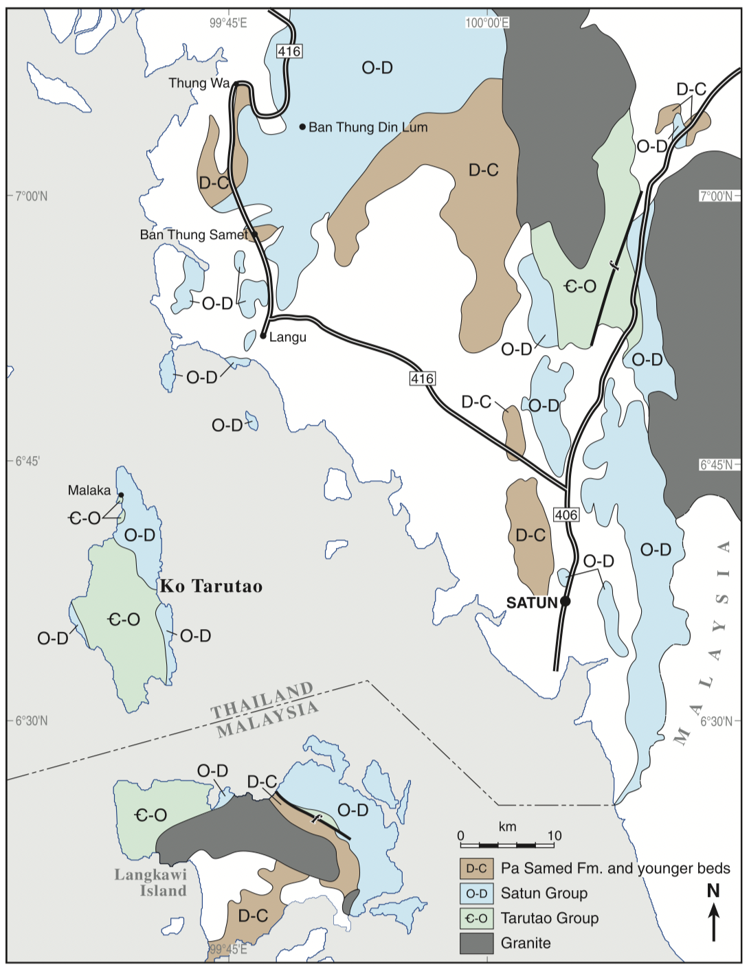
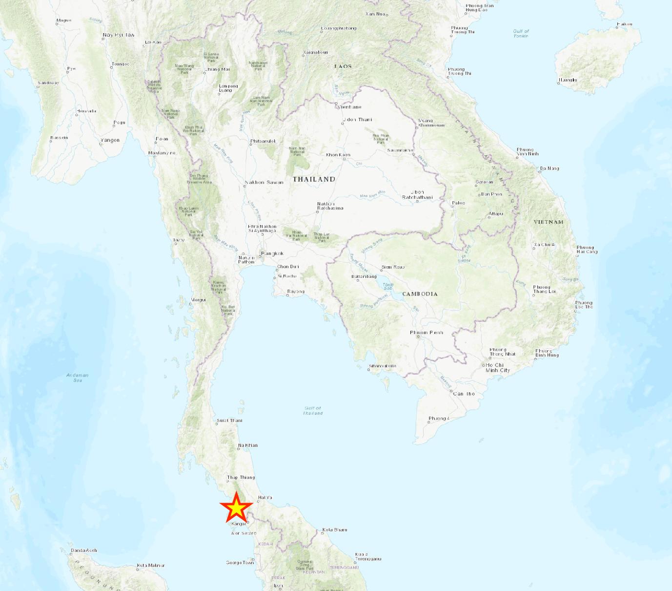
Named after Wang Tong village, 12 km to the north of Langu district, Satun province by Wongwanich et al. (1990). Parent unit: Lowest formation of the Thong Pha Phum Gr (Wongwanich, 1990), but Ridd (2011) assigned it to part of the Satun Gr.
[Figure: Sketch geological map (from various sources) of the southern part of Peninsular Thailand and Langkawi Island of Malaysia. Note that Thai stratigraphic nomenclature has been extended to Langkawi Island (Ridd. 2011)]
Synonym: หมวดหินวังตง
Lithology and Thickness
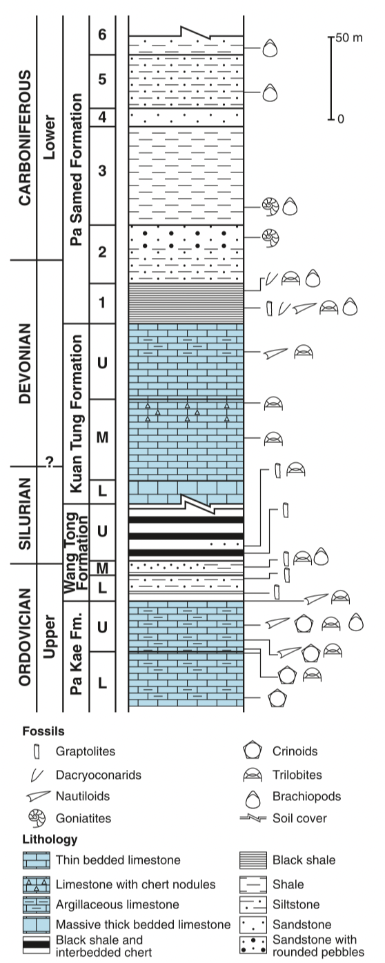
Shale, black with graptolites, in the Lower part; passing up to siltstone, dark grey, and shale, black with graptolites, and interbedded chert in the Upper part. According to Wongwanich et al. (2002) it can be divided into three members, Lower unit is an interval of about 14 m of black graptolitic shale passing up into dark grey siltstone. Middle unit a 7 m interval of grey to pale brown-grey or reddish-brown weathered muddy siltstone and very fine-grained felspathic sandstone with black graptolitic shale bands. Three fossiliferous horizons with trilobites, brachiopods and crinoid debris are present. Upper unit is a 28 m thick sequence of grey, well-bedded chert with black pyritic, graptolitic shale beds. Although only 49 m of Wang Tong Formation is exposed at the type location, Wongwanich et al. (1990) estimate that another c. 64 m is concealed (Ridd, 2011). Thickness: 50-110 m
[Figure: Composite stratigraphic section of the Upper Ordovician to Carboniferous near Ban Thung Samet, between Km 10 and Km 11 on the Langu to Thung Wa road in Satun Province. From Ridd (2011), which is modified after Wongwanich et al. 2002).]
Lithology Pattern:
Claystone
Relationships and Distribution
Lower contact
Upper contact
Kuan Tung Fm (unconformable)
Regional extent
Lower Peninsular.
GeoJSON
{"type":"Feature","geometry":{"type":"MultiPolygon","coordinates":[[[[99.37,9.2],[99.66,9.37],[99.89,9.32],[100.16,8.78],[100.39,7.93],[100.58,6.98],[100.57,6.39],[100.32,6.3],[99.81,6.7],[99.24,7.45],[98.82,8.18],[99.08,8.51],[99.37,9.2]]]]}}
Fossils
Quote from Ridd (2011): Cocks et al. (2005) have reviewed the biostratigraphy of the Wang Tong Formation, noting that its graptolitic shale is of latest Ordovician to early Silurian age and includes the Normalograptus persculptus Zone. From the lowest member of the formation a Hirnantia fauna was identified, of latest Ordovician age and comprising 17 species including the trilobite Mucronaspis mucronata and the brachiopods Onniella, Hirnantia, Mirorthis, Cliftonia, Paromalomenaand Eospiriferina. Cocks et al. (2005) point out that the Hirnantia fauna was widespread at the time of the latest Ordovician glacial episode. Agematsu et al. (2006b) reviewed the graptolite fauna from the lowest member of the Wang Tong Formation. They identified Normalograptus psuedovenustus psuedovenustus and Normalograptus sp., representing the N. persculptus Zone of latest Ordovician age.
Age
Ridd (2011; Fig. 3.3) implies spans Hirnantian to base-Pridoli.
Age Span:
Beginning stage:
Hirnantian
Fraction up in beginning stage:
0.0
Beginning date (Ma):
445.16
Ending stage:
Pridoli
Fraction up in the ending stage:
0.0
Ending date (Ma):
422.96
Depositional setting
Deep Sea
Depositional pattern:
Additional Information
Compiler:
Wen Du - modified from Ridd. M. F., 2011, Chapter3 Lower Palaeozoic in: Ridd, M.F., Barber, A.J., and Grow, M.J., editors, The Geology of Thailand, Geol. Soc. of London.
Lexicon of Stratigraphic Names of Thailand of 2013.
Lexicon of Stratigraphic Names of Thailand of 2013.


